


The Brand-New Natural Atlas Is Here

With unique maps, recording tools, and field guides about all sorts of natural features and creatures in your area, Natural Atlas has everything you need to start building your atlas of nature.
There are many reasons to get outside. It’s relaxing, it’s a way to get exercise and take in the beauty of it all, but to us there’s one thing that nature offers that nothing else can replace: it’s a place of discovery.
Whether you are a hiker, fisherman, wildlife watcher, or rockhound, one of the huge draws of getting outside is not knowing exactly what you’ll encounter, but knowing that you’re hunting for something that sparks your interest in a deep way. There’s nothing like the joy of discovering something you’ve never seen before – whether it’s some animal going about its daily life, some vibrant wildflower, or some rock formation that looks like it belongs on Mars.
This is why we created Natural Atlas – we wanted to create a place that celebrates all of the little details of nature and fosters a spirit of discovery.
What is It?
The brand new Natural Atlas app is much more than just a hiking app or GPS – it’s the first app of its kind that is both an evolving field guide of nature that helps you learn more about your surroundings, and also a field recorder packed with all the practical tools you need to navigate and chronicle your discoveries.
| Hiking Apps | Field Guide Books and Apps | Natural Atlas | |
|---|---|---|---|
| Topo Maps | |||
| Route Measuring | (with automatic snapping to trails & roads) | ||
| Trip Recording | |||
| # of Animal Species | 0 | 100’s | 1.3 million+ |
| # of Plant Species | 0 | 100’s | 400,000+ |
| Species Range Maps | (but small, and non-interactive) | (interactive) | |
| Fish Species by Waterbody | |||
| Local River Levels | |||
| Local Tides | |||
| Local Flora / Fauna according to GPS location | |||
| Local Geologic Formations | |||
| # of Rocks and Minerals | 100’s | 7,000+ | |
| Updated in real-time with observations by users like you |
Navigate with the Best Maps
Knowing where to go, where you are, and where you’ve been are all super important for anyone who explores nature. This is why a core goal of Natural Atlas, since day one, has always been to build the best topo map of nature – something that makes you feel like you’re actually in it.
We wanted a map packed with detail, like nature itself, so for the past 6 years we’ve been hand-crafting a unique map with all sorts of special touches to inspire your next trip outside. With both official data we’ve curated from hundreds of sources, as well as numerous details added by our team, it will surely enrich every part of your outdoor journey, whether you’re planning, navigating, or telling the story afterwards.
Two Brand-New Maps
There are now two brand new maps give you a totally new perspective on your surroundings: Geology and Satellite Public Lands.
Learn About Your Immediate Surroundings
Even in the most familiar environments, it seems that there is always some detail we haven’t noticed before, or something we’ve walked by a million times without knowing its name. The simple question of “what’s that?” is just one of many interesting questions we ask ourselves when outside.
Sometimes we’d like to dive deeper and know more about the things we can’t see, like “What types of fish are in the lake in front of me?”, or “How long ago did this cliff form, and why are there seashells in it?”
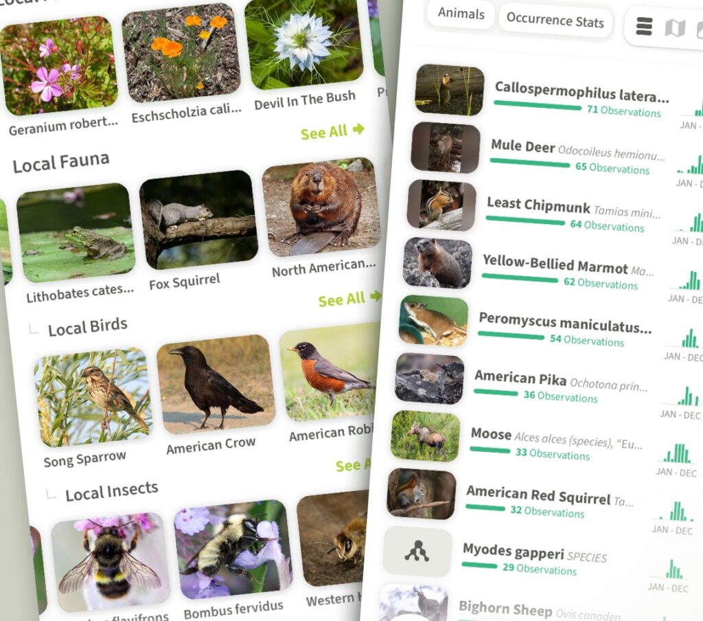
We always wanted to build the field guide of the future – something that can instantly answer these sorts of questions about the exact spot that you are standing – one that uses GPS to automatically present you with local plants, animals, fungi, geology, and more. It’s now here.
The Natural Atlas field guide evolves over time, as it is constructed by analyzing billions of observations of species from a number of sources – one being field notes by Natural Atlas users. So, on your next hike, try noting some plant or animal in your area and you will automatically contribute to everyone’s understanding of that ecosystem.
Build an Atlas of Your Discoveries
In these modern times, it’s easy to be dismissive and say everything’s been explored and there’s nothing new left to discover, but that’s not true. It’s more important now than ever to keep our spirit of discovery alive – recording trips with Natural Atlas makes it easy.
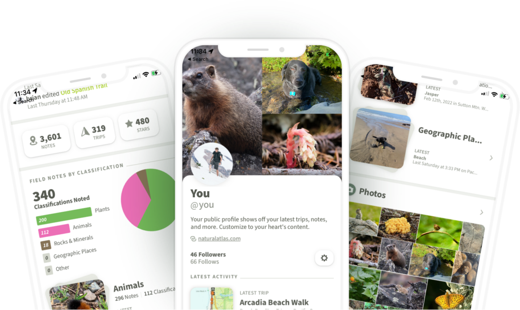
When you record a trip with Natural Atlas you get more than just a photo album, or a track showing where you’ve been – you also start to assemble a rich atlas of nature which automatically organizes your field notes (photos) according to a one-of-a-kind taxonomy of nature, and organizes your trips according to ecosystem.
Recording Trips
and when you notice something interesting, take a quick field note and classify it the best you can. When you get back home, your profile will come alive, showing breakdowns of the plants you’ve encountered, the animals, the rocks, the landforms, and more.
We find that the more trips we record the more curious we become about the natural world, and we think you will too.
Getting Started
We are confident that using Natural Atlas to turn your next hike into a mission to explore the details of nature around you will open your eyes to all sorts of new, interesting things.
To make sure your next trip is successful, we have also packed the app full of useful, practical tools like:
- Route Measuring – easily gauge distances and elevations (with automatic snapping to trails and roads)
- Offline Maps
- Light Conditions – quickly check how much time you have until the sun goes down, or when golden hour is going to begin
- Tide Charts, River Levels
- Print / Download High-Quality Custom PDF Maps
- …and much more
Natural Atlas is free to download in the iOS and Android app stores, as well as online at naturalatlas.com. It’s free to try the basics, but for the full experience we provide the Plus Subscription for $39.99/year.
| Starter Plan (free) | Plus Subscription ($39.99/yr) | |
|---|---|---|
| Topo Map | ||
| Public Lands Map | ||
| Satellite Maps | ||
| Geology Map | ||
| Offline Maps | 300 Blocks | |
| Trip Recording | ||
| Route Measuring | ||
| Local Flora / Fauna | 5 species | all species |
| Local Geology (available in continental USA only) | ||
| Realtime Stream Levels (limited to streams that have gauges) | ||
| Realtime Tides (available in continental USA only) | ||
| Light Conditions Tool (location-specific times when sun and moon rises / sets) |

